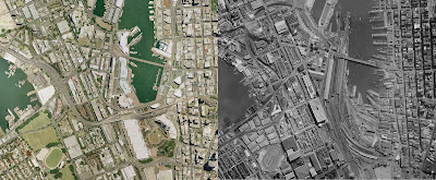
Australian Urban Archaeology – Google Earth Style
I found an interesting toy on the internet a few days ago. The NSW government has released a maps viewer, called Spatial Information eXchange, that looks for all the world like a google earth knock off. They boast that the resolution of the images are better than those used by google earth. While nominally set up to help emergency services and government departments the tool has one trick that google earth/maps doesn’t, satellite imaging from 1943.
The service has been up for a few days but it looks like the server couldn’t handle the initial load. However I was finally able to get consistent service again to produce some present versus past imaging. As some one who didn’t grow up in Australia but live here now it has been very interesting to examine the places I know know as see what they used to look like.
The picture below is an over head of the area around circular quay. The site now occupied by the Sydney Opera House used to be Fort Macquarie tram depot on Bennelog point. The Cahill expressway has yet to be build and join up with the Harbour Bridge.
Also over on the left side of the image is the area known as the hungry mile which has been filled in since 1943 but was recently shut down as an operational port to make way for residential buildings and be renamed “Barangaroo”. Ten years from now it will probably look very different again.
These images are above the area known as Darling harbour. It is currently the location of convention centres, eateries and an IMAX cinema, however it used to be a big shipping yard. It was completely rebuild in the 80s. You can also see the addition of all the elevated roads that carry traffic in and out of the city from the west.
If you know Sydney, or NSW it is definitely worth a look.

